
Route 1 - Top of the Pike
Distance: 3.33km
Duration: 01:07
Difficulty: Moderate
Total Ascent: 177m
Terrain: Bridle paths / open access
Start: Old Hall Inn
Finish: Old Hall In
This walk is great if you are short on time but want the best 360 views. It's worth the short climb.

Route 2 - Around the Pike
Distance: 4.18km
Duration: 01:20
Difficulty: Moderate
Total Ascent: 179m
Terrain: Bridle paths / open access
Start: Old Hall Inn
Finish: Old Hall Inn
This walk is great if you are short on time but want the best 360 views. Its worth the short climb and this route extends the previous along some bridle paths with views of Cracken Edge.

Route 3 - Buxworth Canal Basin
Distance: 4.82km
Duration: 01:22
Difficulty: Easy
Total Ascent: 103m
Terrain: Tramway / lanes
Start: Old Hall Inn
Finish: Old Hall Inn
Very flat out to the basin, along the old tramlines. The basin is steeped in history, and the return can be back along the tramway if you are looking for a very flat route, or, as we have done here, return along the country lanes to make a circular route.

Route 4 - Buxworth Canal Basin & Whaley Basin
Distance: 8.15km
Duration: 02:18
Difficulty: Easy
Total Ascent: 160m
Terrain: Tramway / Lanes / Canal
Start: Old Hall Inn
Finish: Old Hall Inn
An extended version of the Buxworth Basin walk that takes in Whaley Bridge. The Bridge Bake house, which is on the main high street of Whaley Bridge has great cakes, some heated comfy chairs outside to watch the world (village) go by...

Route 5 - Pike Summit, Whaley Basin & Buxworth Basin
Distance: 9.47km
Duration: 02:50
Difficulty: Moderate
Total Ascent: 287m
Terrain: Tramway / Lanes / Canal / Bridleway
Start: Old Hall Inn
Finish: Old Hall Inn
Similar to the route before, explore Buxworth and Whaley canal basins, but get the summit of Eccles Pike with 360 views in first...
Route 6 - Around the Pike, return via Stubbins
Distance: 9.13km
Duration: 02:55
Difficulty: Moderate
Total Ascent: 387m
Terrain: Tramway / lanes / bridleway / fields
Start: Old Hall Inn
Finish: Old Hall Inn
Similar to the route before, explore Buxworth and Whaley canal basins, but get the summit of Eccles Pike with 360 views in first...

Route 7 - Cracken Edge Short
Distance: 6.91km
Duration: 02:14
Difficulty: Moderate
Total Ascent: 313m
Terrain: Footpaths / Fields
Start: Old Hall Inn
Finish: Old Hall Inn
Chinley Churn, or Cracken Edge, is the hill that you see when looking back at the car park. This route takes you high up with great views over South Head and Kinder, with Manchester in the distance (on a fairly clear day!)

Route 8 - Cracken Edge Medium
Distance: 8.89km
Duration: 02:49
Difficulty: Moderate
Total Ascent: 359m
Terrain: Footpaths / Fields
Start: Old Hall Inn
Finish: Old Hall Inn
An extended version of the route before!

Route 9 - Cracken Edge Long
Distance: 11km
Duration: 03:30
Difficulty: Moderate
Total Ascent: 456m
Terrain: Footpaths / fields
Start: Old Hall Inn
Finish: Old Hall Inn
A longer version of the routes before!
Route 10 - South Head
Distance: 11.39km
Duration: 03:29
Difficulty: difficult
Total Ascent: 390m
Terrain: Bridlepath / steep footpaths
Start: Old Hall Inn
Finish: Old Hall Inn
A great walk over to the Hayfield valley, and starting to feel that bit more remote and wild. Great views of the Kinder plateau

Route 11 - Brown Knoll
Distance: 17.51km
Duration: 05.20
Difficulty: medium
Total Ascent: 455m
Terrain: Bridlepath / steep footpaths
Start: Old Hall Inn
Finish: Old Hall Inn
Take a dramatic flagged path directly across the moors (avoid on a rainy days!)

Route 12 - Churn - Mt Famine - South Head
Distance: 17.66km
Duration: 05.45
Difficulty: difficult
Total Ascent: 680m
Terrain: Bridlepath / steep footpaths
Start: Old Hall Inn
Finish: Old Hall Inn
This route starts by taking you up Cracken Edge (the hill you can see from the carpark), down towards Hayfield village, circling back over Mount Famine and South Head with gorgeous views of Kinder Plateau.

Route 13 - Combes Moss
Distance: 18.92km
Duration: 6
Difficulty: difficult
Total Ascent: 594m
Terrain: Bridlepath / steep footpaths
Start: Old Hall Inn
Finish: Old Hall Inn
Wonderful walk exploring the little trodden combs grouse moor, overlooking the lake

Route 14 - Cat / Shining Tor
Distance: 27.19km
Duration: 8.30
Difficulty: extreme
Total Ascent: 874m
Terrain: Bridlepath / steep footpaths
Start: Old Hall Inn
Finish: Old Hall Inn
a scenic Peak District walk that climbs to the highest point in Cheshire, Shining Tor. The route follows airy ridge paths with wide views across the Goyt Valley and surrounding moorland. Passing near Cats Tor, it offers a rewarding mix of ascents and dramatic upland scenery.

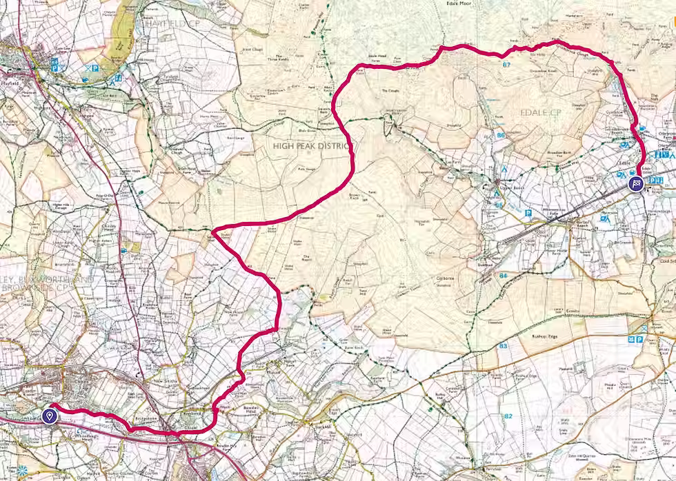
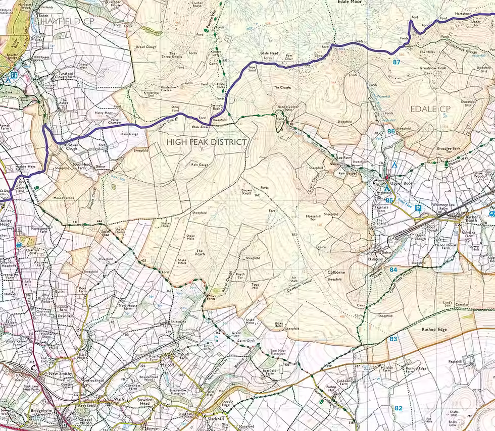
Route 15 - Edale Station via Jacobs Ladder
Distance: 15.43km
Duration: 5hrs
Difficulty: moderate
Total Ascent: 521m
Terrain: Bridlepath / steep footpaths
Start: Old Hall Inn
Finish: Edale Station (8 min return train journey)
The route rewards with expansive views across the Edale Valley and surrounding hills. It then descends back toward Edale Station, offering a satisfying mix of challenge and scenery.
Route 16 - Edale Skyline via Shire Oaks and Brown Knowle
Distance: 16.6km
Duration: 5.15hrs
Difficulty: hard
Total Ascent: 538m
Terrain: Bridlepath / steep footpaths / heather
Start: Old Hall Inn
Finish: Edale Station (8 min return journey)
Check train times here
Crossing the quiet heights of Brown Knowle, it offers wide, expansive views before joining the dramatic Edale Skyline. The route finishes with a rewarding descent toward Edale, surrounded by some of the area’s most iconic landscapes.
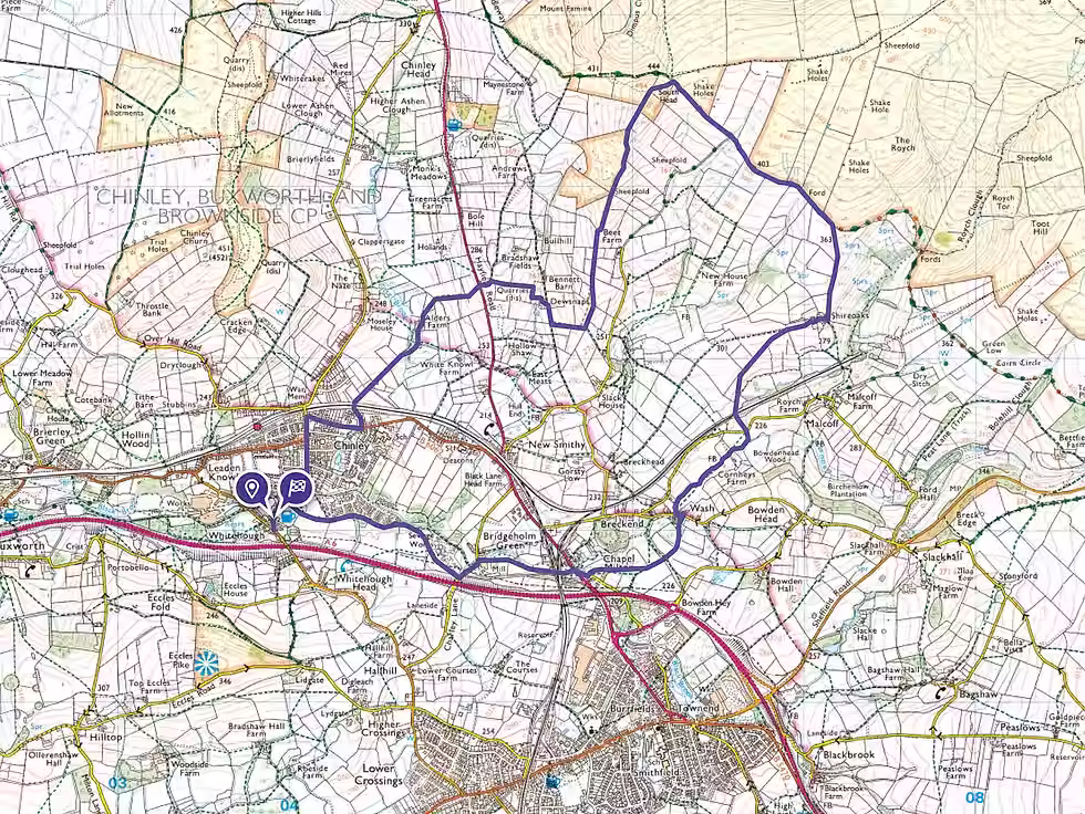
Route 17 - Edale Skyline via Chinley Churn
Distance: 17.37km
Duration: 6hrs
Difficulty: hard
Total Ascent: 817m
Terrain: Bridlepath / steep footpaths / heather
Start: Old Hall Inn
Finish: Edale Station (8 min return journey)
Check train times here
From Chinley Churn, the route joins the Edale Skyline, offering sweeping views across the Hope Valley and surrounding moorlands. It’s a rewarding walk with a mix of rugged upland terrain and iconic ridge-top scenery.

Route 18 - Edale via Snake Path & Churn
Distance: 26km
Duration: 8.45hrs
Difficulty: extreme
Total Ascent: 1109m
Terrain: Bridlepath / steep footpaths / heather
Start: Old Hall Inn
Finish: Edale Station (8 min return journey)
Check train times here
This route follows the Snake Path before climbing to Chinley Churn, where panoramic vistas open across the Hope Valley. It then descends toward Edale, offering a rewarding finish through classic upland scenery.